


MISSISSIPPI — UPDATE: The watch has expired.
—
A Tornado Watch has been issued for portions of southern Mississippi as severe thunderstorms capable of producing tornadoes, damaging winds and heavy rainfall move through the region Thursday.
The National Weather Service’s Storm Prediction Center issued Tornado Watch 351, which remains in effect until 5 p.m. CDT Thursday.
The watch includes Forrest, George, Greene, Hancock, Harrison, Jackson, Jones, Lamar, Marion, Pearl River, Perry, Stone and Wayne counties.
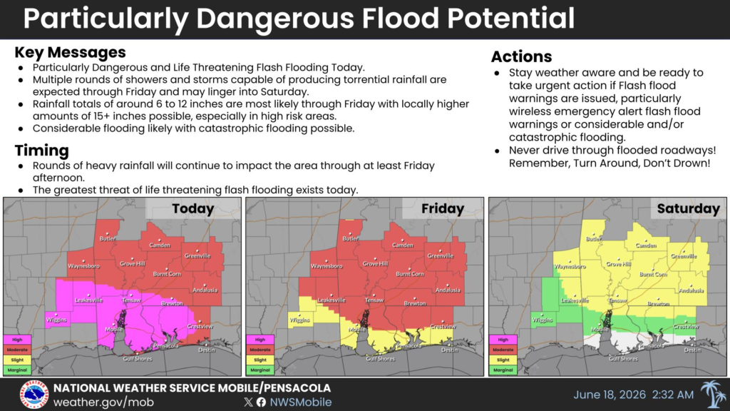
In addition to the tornado threat, the National Weather Service in Mobile is warning of particularly dangerous and life-threatening flash flooding across southern Mississippi today. Forecasters say multiple rounds of showers and thunderstorms capable of producing torrential rainfall are expected through Friday and could linger into Saturday.
Rainfall totals of 6 to 12 inches are expected across much of the region through Friday, with isolated locations potentially receiving more than 15 inches. Officials warn that considerable flooding is likely, with catastrophic flooding possible in the hardest-hit areas. The greatest threat for life-threatening flash flooding is expected today, with rounds of heavy rain continuing through at least Friday afternoon.
Residents are urged to stay weather aware and be prepared to take immediate action if Flash Flood Warnings are issued, especially Wireless Emergency Alert notifications indicating considerable or catastrophic flash flooding.
Officials also remind motorists never to drive through flooded roadways, emphasizing the safety message: “Turn Around, Don’t Drown.”
The National Weather Service encourages residents to monitor forecasts through its Facebook and X social media pages or by listening to NOAA Weather Radio for the latest weather information and warnings.


