


OKLAHOMA — UPDATE: The watches have expired.
—
A Tornado Watch remains in effect until 10 p.m. CDT Thursday for much of northern, central and northeastern Oklahoma as thunderstorms capable of producing tornadoes, damaging winds and large hail develop across the region.
According to the National Weather Service and Storm Prediction Center, the watch includes 31 Oklahoma counties: Adair, Alfalfa, Beaver, Blaine, Cherokee, Craig, Creek, Delaware, Dewey, Ellis, Garfield, Grant, Harper, Kay, Kingfisher, Logan, Major, Mayes, Noble, Nowata, Osage, Ottawa, Pawnee, Payne, Rogers, Roger Mills, Tulsa, Wagoner, Washington, Woods and Woodward.
Communities included in or near the watch area include Enid, Stillwater, Guthrie, Kingfisher, Perry, Ponca City, Woodward, Alva, Cherokee, Watonga, Fairview, Beaver and Tulsa, among many others.
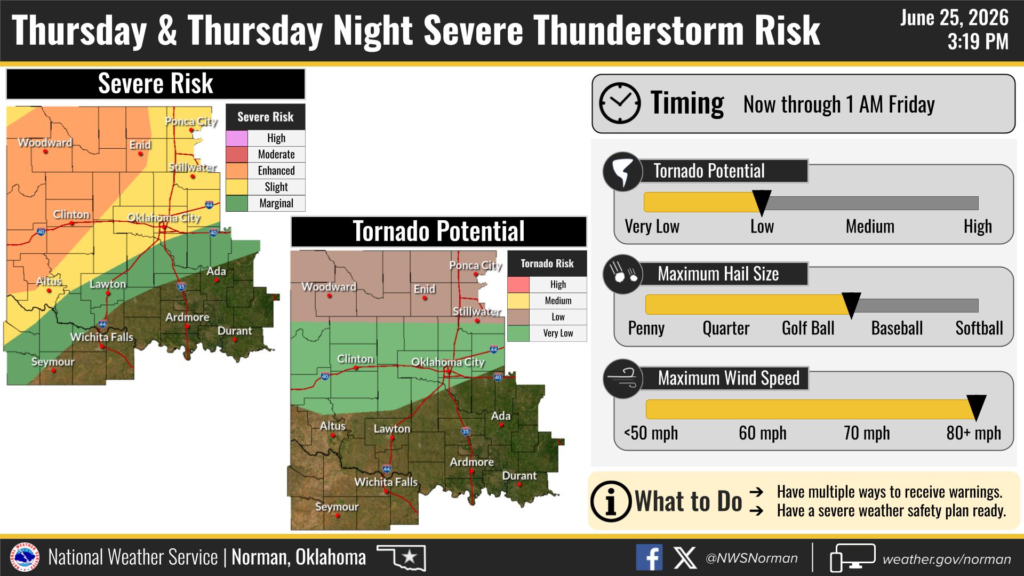
The National Weather Service in Norman says the greatest threat period extends from Thursday afternoon through 10 p.m., while the overall severe weather risk continues into the overnight hours. Forecasters say storms will be capable of producing wind gusts exceeding 80 mph, hail up to golf ball size, and a low, but not zero, tornado threat. The greatest overall severe weather risk is across northern and western Oklahoma, where an enhanced risk of severe thunderstorms is in place.
Residents in the watch area are encouraged to monitor weather conditions closely, have multiple ways to receive warnings, and be prepared to seek shelter quickly if a Tornado Warning is issued.


