


ILLINOIS — A Tornado Watch has been issued for a large portion of Illinois until 3 p.m. CDT Wednesday as forecasters warn of multiple rounds of severe thunderstorms capable of producing strong tornadoes, damaging winds, large hail and flash flooding.
Tornado Watch 340 includes 46 Illinois counties stretching across central, western and northern portions of the state, including Champaign, Vermilion, Sangamon, Peoria, McLean, La Salle, Tazewell, Macon, Shelby and Douglas counties.
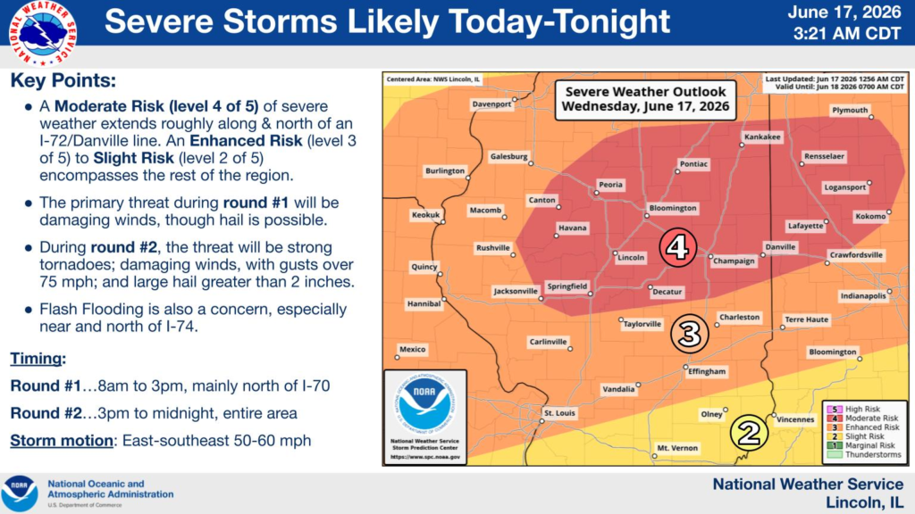
According to forecasters, multiple rounds of severe weather are expected throughout the day and into the evening. One round of storms is anticipated during the morning hours, with another expected from mid-afternoon through the evening.
Much of central and northern Illinois is under a Moderate Risk (Level 4 out of 5) for severe weather, generally along and north of the Interstate 72 corridor and the Danville area. Areas farther south remain under an Enhanced Risk (Level 3) to Slight Risk (Level 2).
Meteorologists warn that the greatest threat is expected during the afternoon and evening hours when atmospheric conditions could support strong tornadoes, widespread damaging wind gusts, large hail and localized flash flooding.
Residents in the watch area are urged to closely monitor forecasts, have multiple ways to receive weather warnings and be prepared to take shelter quickly if warnings are issued.


