


VIRGINIA — UPDATE: The watches have expired.
—
A Severe Thunderstorm Watch has been issued for a large portion of eastern Virginia through 8 p.m. Tuesday as forecasters warn that strong to severe thunderstorms could produce damaging winds, hail, isolated tornadoes, and localized flash flooding.
According to the National Weather Service’s Storm Prediction Center, the watch includes dozens of counties and independent cities across central, eastern, and coastal Virginia, including the Richmond and Hampton Roads regions.
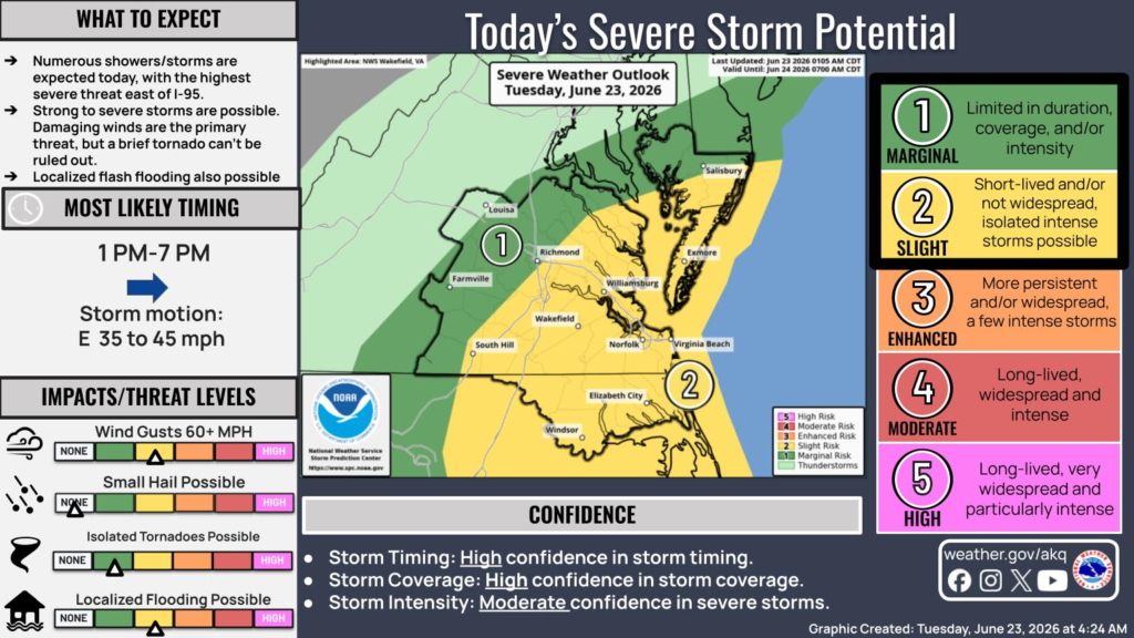
The National Weather Service in Wakefield says numerous showers and thunderstorms are expected to develop Tuesday, with the greatest threat for severe weather east of Interstate 95. Damaging wind gusts of 60 mph or greater are expected to be the primary hazard, although small hail and a brief tornado are also possible. Heavy rainfall could also lead to localized flash flooding in poor drainage and low-lying areas.
Storms are expected to be most active between 1 p.m. and 7 p.m., moving east at 35 to 45 mph.
Areas under the watch include the counties of Accomack, Amelia, Brunswick, Caroline, Charles City, Chesterfield, Dinwiddie, Essex, Gloucester, Goochland, Greensville, Hanover, Henrico, Isle of Wight, James City, King and Queen, King George, King William, Lancaster, Lunenburg, Mathews, Mecklenburg, Middlesex, New Kent, Northampton, Northumberland, Nottoway, Powhatan, Prince George, Richmond, Southampton, Surry, Sussex, Westmoreland and York.
The watch also includes the independent cities of Chesapeake, Colonial Heights, Emporia, Franklin, Hampton, Hopewell, Newport News, Norfolk, Petersburg, Poquoson, Portsmouth, Richmond, Suffolk, Virginia Beach and Williamsburg.
Forecasters have high confidence in the timing and coverage of storms but only moderate confidence in how intense the strongest storms will become. Residents are encouraged to monitor forecasts throughout the day and be prepared to seek shelter quickly if severe thunderstorm or tornado warnings are issued.


