


ILLINOIS — A Flood Watch has been issued for portions of Illinois beginning Thursday afternoon as forecasters warn that repeated rounds of thunderstorms could bring heavy rainfall and increase the risk of flooding through the end of the week.
The National Weather Service has issued two Flood Watches covering much of central, southern and eastern Illinois, with the first taking effect Thursday afternoon and continuing through Friday morning for Bond, Calhoun, Clinton, Fayette, Greene, Jersey, Macoupin, Madison, Marion, Monroe, Montgomery, St. Clair and Washington counties.
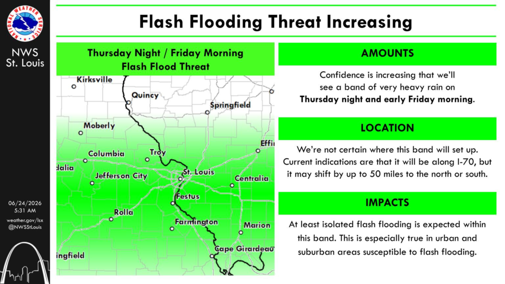
Forecasters say flash flooding caused by excessive rainfall is possible as multiple waves of thunderstorms move across the region. Excessive runoff could lead to flooding of rivers, creeks, streams and other low-lying or flood-prone areas.
Communities included in the watch area include Alton, Belleville, Centralia, Edwardsville, Litchfield, Salem, Vandalia and surrounding areas.
A second Flood Watch has been issued for portions of central, east-central and southeast Illinois from Thursday afternoon through Saturday afternoon. Counties included are Christian, Shelby, Moultrie, Coles, Clark, Cumberland, Effingham, Jasper, Crawford, Clay, Richland and Lawrence.
The National Weather Service said recent rounds of rainfall have left the ground saturated, meaning it will take less additional rain to produce flooding. Forecast guidance indicates there is a greater than 70% chance that some locations within the watch area will receive more than 2 inches of rainfall.
Residents in both watch areas are urged to monitor the latest forecasts and be prepared to take action if Flood Warnings are issued. Those living in flood-prone locations should remain alert for rapidly changing conditions through the weekend.


