


KENTUCKY — A Flood Watch has been issued for much of northern and eastern Kentucky from Friday afternoon through Saturday morning as multiple rounds of showers and thunderstorms are expected to bring heavy rainfall and increase the risk of flash flooding.
The National Weather Service said the watch includes Boone, Bracken, Boyd, Campbell, Carroll, Carter, Elliott, Fleming, Gallatin, Grant, Greenup, Johnson, Kenton, Lawrence, Lewis, Mason, Martin, Menifee, Montgomery, Morgan, Owen, Pendleton, Powell, Robertson, Rowan and Bath counties.
Forecasters warn that repeated rounds of thunderstorms could produce excessive rainfall, resulting in flooding of rivers, creeks, streams and other low-lying or flood-prone areas. Flooding may also develop in poor drainage locations and on roadways.
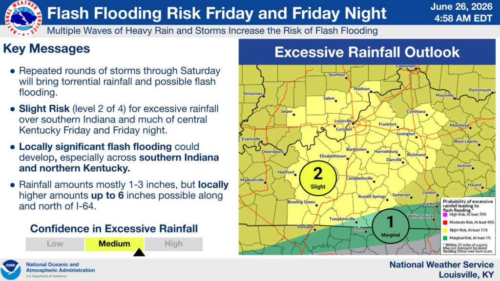
Rainfall totals of 1 to 2 inches are expected across much of the watch area, with localized amounts of up to 4 inches possible where thunderstorms repeatedly move over the same locations. The greatest flooding threat will occur where storms train over the same areas for several hours.
The National Weather Service’s Weather Prediction Center places much of northern Kentucky under a Level 2 of 4 risk for excessive rainfall, indicating scattered instances of flash flooding are possible. Additional rounds of heavy rain are expected to continue into Saturday morning.
Residents, especially those living in flood-prone areas, are urged to closely monitor the latest forecasts and be prepared to take action if Flash Flood Warnings are issued. Motorists should never drive through flooded roadways and should remember the safety message: “Turn Around, Don’t Drown.”


