


KANSAS — Multiple schools across Kansas could face closures, delayed starts or early dismissals Monday as forecasters warn of a potentially dangerous severe weather outbreak expected to bring tornadoes, destructive winds, giant hail and possible power outages.
According to the National Weather Service Storm Prediction Center, central Kansas is under a moderate risk for severe thunderstorms Monday, the second-highest threat category issued by the agency. Additional portions of the state are included in an enhanced or slight risk area.
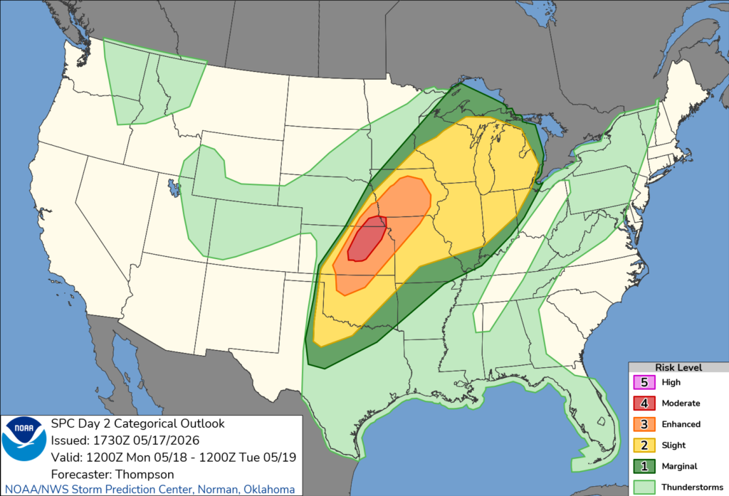
Forecasters said numerous severe thunderstorms are expected to develop Monday afternoon and evening along a cold front and dryline stretching across the Plains. The Storm Prediction Center specifically highlighted cities including Salina, Manhattan, Hutchinson, Newton and Junction City in the moderate risk zone, while Wichita and Kansas City were listed in the enhanced risk area.
Meteorologists warned that supercell thunderstorms capable of producing very large hail and strong to intense tornadoes are likely from central Kansas into southeast Nebraska. Damaging straight-line winds and heavy rainfall are also expected as storms grow into larger clusters Monday night.
The severe weather threat has raised concerns that some Kansas school districts could cancel classes, delay openings or dismiss students early if storms cause widespread power outages, flooded roads, downed trees or damage to school buildings and nearby communities.
Forecasters said atmospheric conditions Monday will be highly favorable for severe weather, with rich Gulf moisture, extreme instability and strengthening wind shear supporting the development of dangerous storms.
School officials across Kansas are expected to closely monitor forecast updates, watches and warnings from the National Weather Service through Monday morning as the storm system approaches.


