


WISCONSIN — UPDATE: The watches have expired.
—
The National Weather Service’s Storm Prediction Center has issued a Severe Thunderstorm Watch for much of Wisconsin until 10 p.m. CDT Wednesday as another round of strong to severe storms is expected to develop across the state.
The watch includes much of central, southern and eastern Wisconsin, including Adams, Brown, Calumet, Clark, Columbia, Crawford, Dane, Dodge, Fond du Lac, Forest, Grant, Green, Green Lake, Iowa, Jackson, Jefferson, Juneau, Kenosha, Lafayette, Langlade, La Crosse, Lincoln, Manitowoc, Marathon, Marinette, Marquette, Menominee, Milwaukee, Monroe, Oconto, Oneida, Outagamie, Ozaukee, Portage, Racine, Richland, Rock, Sauk, Shawano, Sheboygan, Vernon, Walworth, Washington, Waukesha, Waupaca, Waushara, Winnebago and Wood counties.
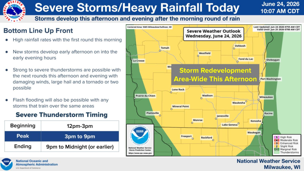
According to the National Weather Service in Milwaukee/Sullivan, a morning round of heavy rain is expected to be followed by redevelopment of thunderstorms during the afternoon and evening. The strongest storms could produce damaging wind gusts, large hail and the possibility of one or two tornadoes.
Forecasters also warn that heavy rainfall could lead to flash flooding, particularly in areas where storms repeatedly move over the same locations.
Storms are expected to begin developing between noon and 3 p.m., with the greatest threat occurring from 3 p.m. to 9 p.m. The severe weather threat is expected to diminish between 9 p.m. and midnight, or earlier.
Residents in the watch area are encouraged to monitor the latest forecasts and be prepared to take shelter if severe thunderstorm or tornado warnings are issued.


