


NEW JERSEY — Residents across portions of New Jersey should prepare for the potential for flash flooding Monday afternoon and night as the National Weather Service has issued Flood Watches covering much of the state.
A Flood Watch is in effect from 2 p.m. Monday through late Monday night for Camden, Gloucester, Hunterdon, Mercer, Middlesex, Morris, Burlington, Salem and Somerset counties. A separate Flood Watch is also in effect during the same time period for Bergen, Essex, Hudson, Passaic and Union counties.
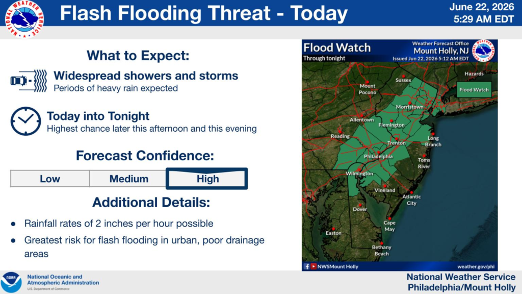
Forecasters say showers and thunderstorms are expected to develop this afternoon and continue into the evening, producing rainfall rates of up to 2 inches per hour. Most locations are expected to receive 1 to 2 inches of rain, although localized totals of up to 3 inches are possible.
The National Weather Service warns that the heavy rainfall could lead to flash flooding, especially in urban areas, poor-drainage locations and low-lying areas. Excessive runoff may also cause flooding along small streams and creeks.
According to the forecast, the greatest risk for flash flooding will occur later this afternoon and evening as widespread showers and thunderstorms move across the state. Forecast confidence in the flooding threat is high.
Residents are urged to closely monitor changing weather conditions and be prepared to take action if Flash Flood Warnings are issued. Motorists are reminded never to drive through flooded roadways, as floodwaters can quickly become deeper and more dangerous than they appear.


