


INDIANA — A Flood Watch remains in effect for much of central, west central, south central, southwest and parts of southeast Indiana from Sunday afternoon through Monday morning as forecasters warn that repeated rounds of thunderstorms could bring heavy rainfall and flooding.
According to the National Weather Service in Indianapolis, excessive rainfall may produce flooding along rivers, creeks, streams and other low-lying or flood-prone areas. Rainfall totals of up to 3 inches are expected across the watch area, with locally higher amounts possible where storms repeatedly move over the same locations.
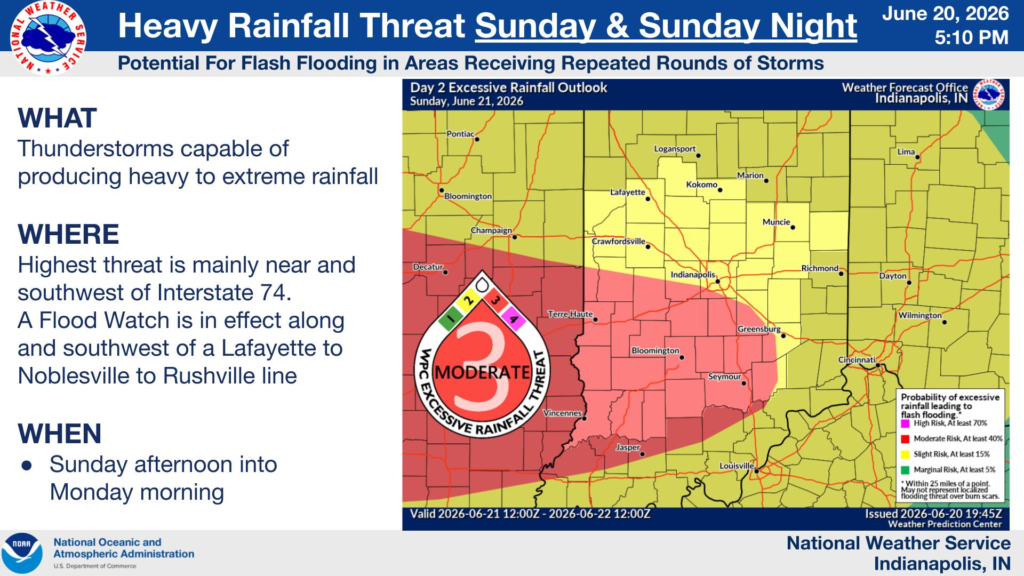
The Weather Prediction Center has placed portions of southwestern and central Indiana under a moderate risk for excessive rainfall, indicating an increased potential for flash flooding. The highest threat is expected mainly near and southwest of Interstate 74, where repeated thunderstorms could produce heavy to extreme rainfall Sunday afternoon through overnight into Monday morning.
The Flood Watch includes numerous counties, including Marion, Hamilton, Boone, Hendricks, Johnson, Shelby, Rush, Morgan, Monroe, Brown, Bartholomew, Vigo, Tippecanoe, Putnam, Clay, Parke, Vermillion, Sullivan, Greene, Knox, Daviess, Martin, Lawrence, Jackson, Jennings and several others. Cities within the watch include Indianapolis, Lafayette, Terre Haute, Bloomington, Columbus, Carmel, Fishers, Greenwood, Franklin, Shelbyville, Seymour, Bedford, Vincennes and Crawfordsville.
Forecasters urge residents to monitor the latest weather forecasts and remain alert for possible Flood Warnings. Those living in areas that are prone to flooding should be prepared to take action if flooding develops and avoid driving through flooded roadways.


