


OHIO — Lake-enhanced snow showers are expected to return to portions of Northeast Ohio and Northwest Pennsylvania tonight, bringing another round of winter weather to the region, according to the National Weather Service.
Forecasters say snow showers will develop this evening and continue through Sunday, primarily affecting areas within the primary snowbelt.
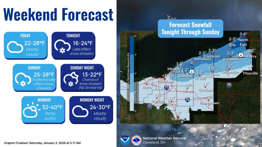
The highest snowfall totals are expected near Lake Erie, where accumulations of 2 to 4 inches are possible in parts of northern Erie County, Pennsylvania, and far northeast Ohio. Communities such as Conneaut, Ashtabula, and North East, Pennsylvania could see 2 to 3 inches, while inland snowbelt locations may receive 1 to 2 inches.
Outside of the main snowbelt, lighter snowfall is expected. Many areas farther south and west, including portions of central and southern Northeast Ohio, may see less than one inch of accumulation.
Temperatures will remain cold throughout the weekend, with daytime highs generally in the 20s and overnight lows dropping into the teens. Snow showers are expected to gradually taper off late Sunday into Sunday night.
Looking ahead, the National Weather Service says temperatures should begin to moderate early next week, with highs climbing into the 30s and possibly near 40 degrees by Monday afternoon, offering a brief break from the persistent cold.


