


OHIO — Ohio residents can expect two rounds of snow showers from Friday into Saturday, with light accumulations at first and a better chance for measurable snowfall overnight, according to weather officials.
The National Weather Service forecast shows the first round of snow arriving during the daytime hours on Friday. This initial round is expected to bring light snow showers across much of Ohio.
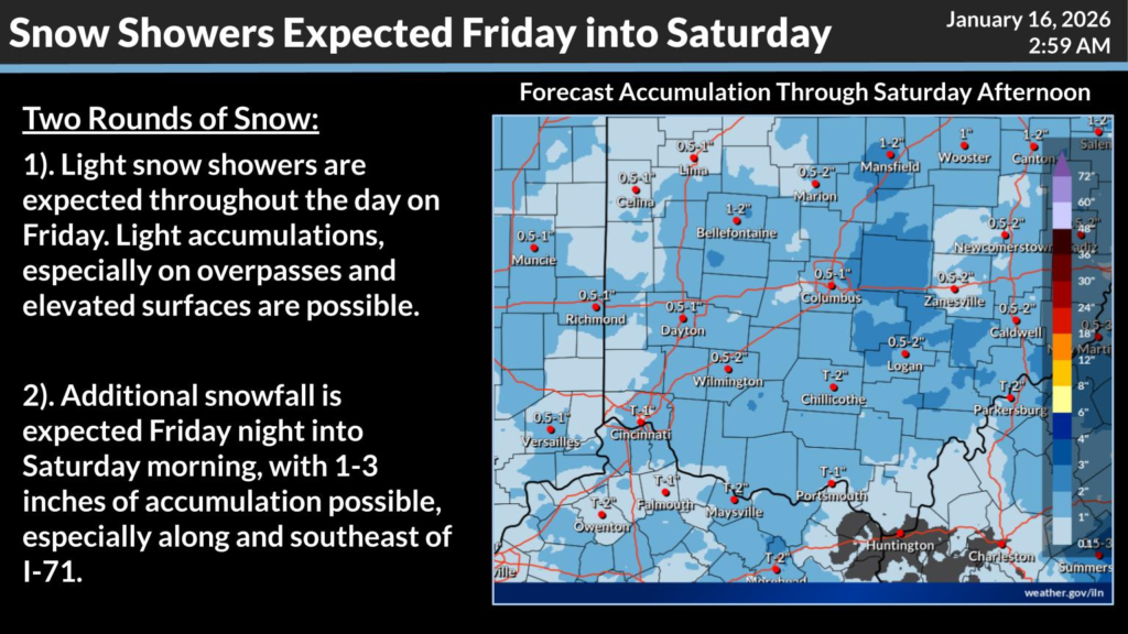
Accumulations during the day are forecast to be minor, with snow mainly sticking to grassy areas, overpasses, bridges, and other elevated surfaces. Road impacts during the daytime are expected to be limited, though drivers are urged to use caution, especially on untreated surfaces.
A second round of snow is forecast to move into the state Friday night and continue into Saturday morning. This round is expected to produce more widespread accumulation.
Forecast models indicate that many areas could see between 1 and 3 inches of snow, with the highest totals most likely along and southeast of Interstate 71. Areas in central and southeastern Ohio, including portions of the Columbus, Zanesville, Logan, and Chillicothe regions, appear more likely to see accumulations near the upper end of that range.
Snow showers are expected to taper off by Saturday afternoon. Forecasters say travel impacts could increase Friday night into early Saturday, particularly in areas receiving heavier snowfall. Residents are encouraged to monitor local forecasts and road conditions as the system moves through the state.


