


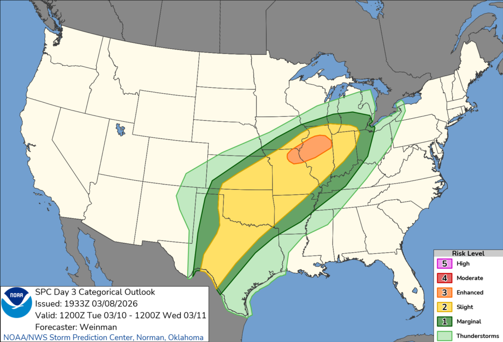
ILLINOIS — The National Weather Service’s Storm Prediction Center has placed portions of northern and central Illinois under an Enhanced Risk (Level 3 of 5) for severe thunderstorms on Tuesday as a large storm system moves across the central United States.
According to the Storm Prediction Center outlook issued Sunday evening, scattered severe thunderstorms are expected to develop from the southern Plains into the southern Great Lakes region during the day Tuesday and continue into the overnight hours. Illinois lies within a corridor where multiple severe weather hazards will be possible, including damaging winds, large hail and tornadoes.
The Enhanced Risk area includes parts of northern and central Illinois, along with northeast Missouri and far southeast Iowa. Surrounding areas of Illinois fall within a Slight Risk (Level 2) or Marginal Risk (Level 1) for severe weather.
Meteorologists say the threat will develop as a complex weather pattern takes shape across the country. A strong upper-level trough moving from northern Mexico and the Southwest toward the southern Plains will interact with another system strengthening across the northern Plains and Upper Midwest.
At the surface, a nearly stationary warm front is expected to stretch eastward into the southern Great Lakes region from a weak low pressure system over the middle Mississippi Valley.
South of that boundary, warm and humid air will surge northward across the Midwest, with dew points expected to reach the mid to upper 60s, creating an environment favorable for thunderstorm development.
Forecasters say a strengthening low-level jet during the evening and overnight hours will increase wind shear in the atmosphere. This combination of strong winds aloft and abundant moisture could allow storms to organize into clusters of supercells, which are capable of producing the most intense severe weather.
If these storms form, they could produce damaging wind gusts, large hail and a few tornadoes, with some tornadoes potentially strong. Storms that develop over the middle Mississippi Valley could also move northeast toward Illinois and the southern Great Lakes overnight, though forecasters say confidence in the exact evolution of storms remains uncertain several days out.
Because of the potential for severe weather, residents across Illinois are encouraged to monitor updated forecasts and watches as Tuesday approaches, since details about the timing and exact location of storms may change.


