


WEST VIRGINIA — A powerful winter storm is set to blanket much of West Virginia with heavy snow and strong winds beginning early Sunday morning, creating hazardous travel conditions that could force schools to close for multiple days next week.
The National Weather Service has issued Winter Storm Warnings for large portions of the state from 1 a.m. Sunday through 1 a.m. Tuesday. Forecasters say snowfall totals will range from 3 to 12 inches depending on location, with higher elevations receiving the greatest accumulations. Wind gusts could reach 35 to 45 mph, leading to blowing snow and near-whiteout conditions at times.
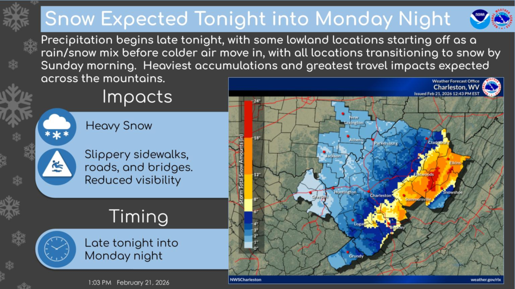
Central and Southern West Virginia
Communities including Beckley, Oak Hill, Fayetteville, Summersville, Richwood, Craigsville, Sutton, Webster Springs, Clay, and Elkins are expected to receive between 5 and 12 inches of snow. Wind gusts up to 45 mph could create drifting snow and sharply reduced visibility.
In Mercer and Summers counties, including Bluefield, Flat Top, Hinton and Hix, snowfall totals of 3 to 5 inches are forecast, along with gusts up to 35 mph. Western Greenbrier County, including Rainelle and Quinwood, could see between 5 and 10 inches of snow with wind chills near zero Sunday night as temperatures drop into the teens.
Kanawha Valley and Surrounding Counties
Charleston, South Charleston, Hurricane, Ripley, Spencer, Clarksburg and surrounding communities are forecast to receive 3 to 5 inches of snow. While totals may be slightly lower than mountain areas, slick roads and reduced visibility are still expected to significantly impact travel.
Northeastern and Mountain Counties
Preston, Tucker, Randolph and Pocahontas counties — including communities such as Kingwood, Parsons, Thomas, Davis, Elkins and Snowshoe — could see between 6 and 12 inches of snow, with locally higher amounts along ridge tops. Strong winds may bring down tree branches and power lines, increasing the risk of scattered power outages.
Western Grant and Western Pendleton counties are also under a Winter Storm Warning, with 6 to 12 inches possible in higher elevations.
School Impacts Likely
With snow beginning early Sunday and continuing through Monday night, road conditions are expected to remain hazardous for several days. The storm is forecast to impact both the Monday morning and evening commutes, and drifting snow could keep secondary roads slick into Tuesday.
Given the projected snowfall totals, blowing snow and potential power outages, school districts across central, southern and northeastern West Virginia may be forced to cancel classes Monday. Additional closures or delays Tuesday are also possible if road crews are unable to clear snow and ice quickly, particularly in mountain and rural counties.
Officials urge residents to avoid unnecessary travel, prepare emergency kits for vehicles and monitor local forecasts for updates. Motorists can check current road conditions by calling 511.
Additional updates are available through the National Weather Service and local emergency management agencies.


