


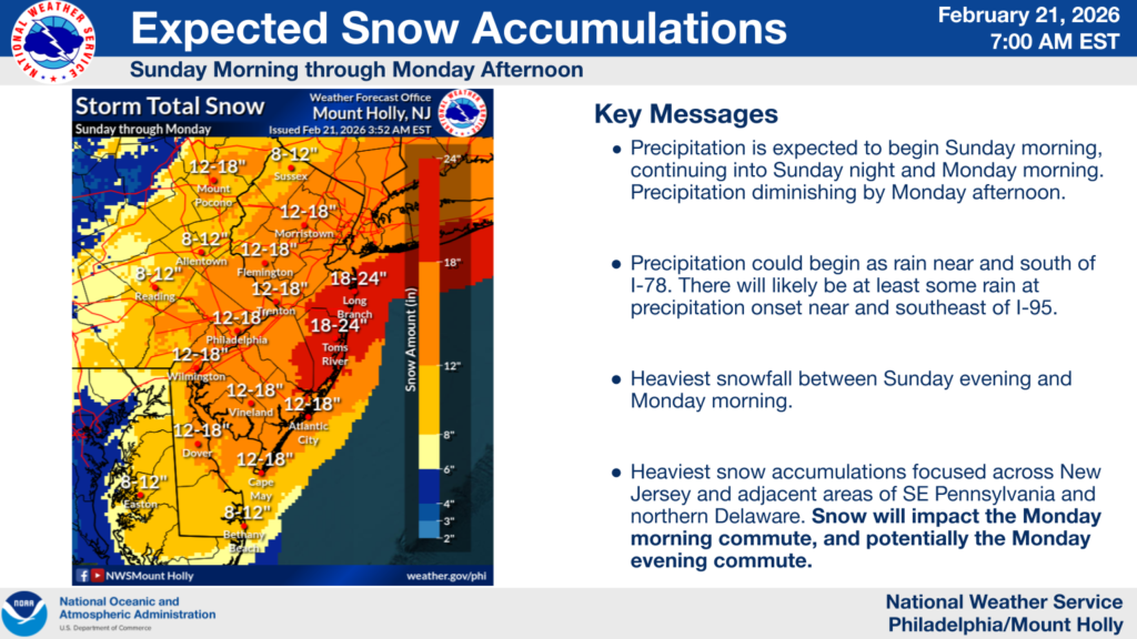
NEW JERSEY — A powerful late-winter storm is set to slam New Jersey with heavy snow, strong winds and blizzard conditions beginning Sunday and lasting into Monday, according to the National Weather Service.
Blizzard Warnings are in effect from 10 a.m. Sunday until 6 p.m. Monday for large portions of the state, including coastal and inland counties along and near the Atlantic. Snow totals are projected to be significant, with some areas expected to receive 20 to 24 inches of snow in eastern Monmouth and Ocean counties — among the highest amounts forecast in the state.
Counties under Blizzard Warning include Monmouth, Ocean, Mercer, Middlesex, Morris, Somerset, Camden, Cumberland, Gloucester, and Northwestern Burlington, as well as coastal Atlantic and Cape May counties.
In these areas, the National Weather Service warns that travel could become very difficult or impossible at times due to whiteout conditions caused by heavy snow and strong winds gusting up to 50 mph. Visibility is expected to fall well below a quarter-mile during peak snowfall, and snow drifts could make roadways treacherous.
The storm’s track also includes Winter Storm Warnings for other parts of New Jersey not under the blizzard criteria, with heavy snow and impacts to daily commuting expected statewide, particularly Sunday night and Monday.
Officials caution that heavy, blowing snow combined with gusty winds could lead to downed tree limbs, power outagesand widespread travel disruptions. Residents are advised to monitor weather updates and heed travel advisories as the weekend storm system intensifies.


