


INDIANA — The National Weather Service’s Storm Prediction Center has placed much of Indiana under a Slight Risk (Level 2 of 5)for severe thunderstorms Thursday afternoon into early evening.
Forecasters say severe storms are expected to develop across portions of the middle Mississippi Valley and lower Ohio Valley, including parts of Indiana, as a strong weather system moves from the Plains into the Midwest.
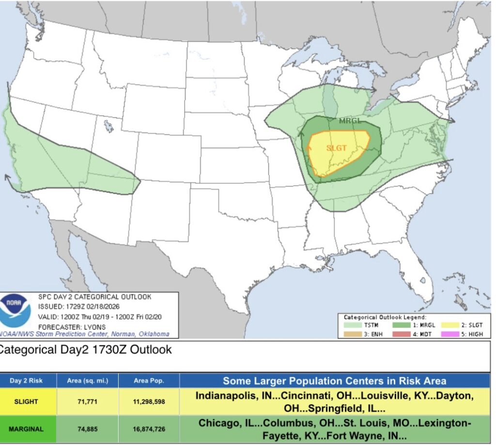
According to the outlook, thunderstorms that form Thursday could produce damaging wind gusts, large hail and a few tornadoes.
What’s Driving the Threat
Meteorologists say a strong upper-level disturbance and a rapidly strengthening surface low-pressure system will move toward the Great Lakes by early Friday. As the system approaches, moisture will increase across Indiana and surrounding states.
Although moisture levels are not unusually high for this time of year, forecasters expect enough daytime heating and atmospheric instability to allow storms to intensify. Wind speeds higher in the atmosphere are forecast to exceed 100 mph, creating strong wind shear — a key ingredient for rotating storms.
Storms are expected to develop first to the west during mid-afternoon and move quickly eastward into Indiana. Some of these storms could become supercells, a type of thunderstorm capable of producing large hail and tornadoes.
Strong low-level wind shear near a warm front could also increase the tornado threat in parts of the state.
Potential Impacts in Indiana
If storms develop as forecast, impacts could include:
- Downed trees and power lines from damaging winds
- Large hail capable of damaging vehicles and roofs
- Isolated tornadoes
- Brief but heavy rainfall
While forecasters note that instability will be somewhat limited, the strength of the wind fields means even modest storms could become severe.
Storm intensity is expected to gradually weaken later Thursday evening as the system moves east and atmospheric support decreases.
How This Could Lead to School Closures
Because the severe weather is expected during the afternoon and early evening hours, it could coincide with student dismissal times across Indiana.
If tornado warnings or severe thunderstorm warnings are issued during dismissal, schools may need to:
- Delay bus departures
- Shelter students in place until storms pass
- Cancel after-school activities
- Consider early dismissals if confidence in severe weather increases
Additionally, if storms cause widespread power outages or road blockages, some districts could face delayed openings or closures Friday morning while cleanup efforts are underway.
School officials typically coordinate closely with local emergency management and the National Weather Service when severe weather threatens.
Residents are encouraged to monitor updated forecasts and have multiple ways to receive weather warnings Thursday afternoon.


