


MICHIGAN — Multiple winter storm watches have been issued across northern Michigan, with forecasters warning of heavy snow, ice and gusty winds from Tuesday evening through Wednesday evening.
The National Weather Service offices in Gaylord and Marquette say the storm could bring a mix of snow, sleet and freezing rain, creating hazardous travel conditions across both Northern Lower Michigan and the Upper Peninsula.
Northern Lower Michigan
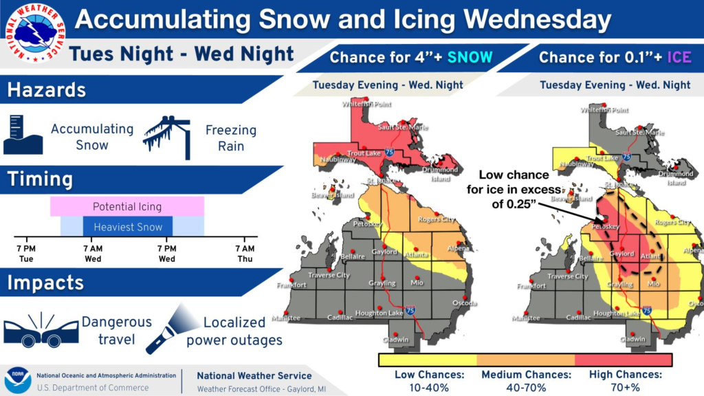
A winter storm watch is in effect from Tuesday evening through Wednesday evening for Alpena, Cheboygan, Emmet, Montmorency and Presque Isle counties.
Forecasters say heavy mixed precipitation is possible, with total snow and sleet accumulations between 2 and 5 inches and ice accumulations up to one-tenth of an inch. Wind gusts could reach 35 mph.
Roads are expected to become slippery, and the hazardous conditions could affect both the Wednesday morning and evening commutes.
Additional counties in Northern Lower Michigan — including Antrim, Otsego, Kalkaska, Crawford, Oscoda, Alcona, Roscommon, Ogemaw, Iosco and Charlevoix — are also under a winter storm watch from Tuesday evening through Wednesday evening.
In those areas, up to 2 inches of snow and sleet are possible, along with ice accumulations around one-quarter of an inch. Wind gusts may reach 35 mph. Officials warn that the heavier icing could lead to tree damage and scattered power outages, in addition to difficult travel.
Eastern Upper Michigan
Western, Central and Southeast Chippewa County, along with Mackinac County and Mackinac Island, are under a winter storm watch from late Tuesday night through Wednesday evening.
Heavy snow is possible, with totals between 4 and 8 inches. Snow may mix with freezing rain at times, and up to one-tenth of an inch of ice is possible. Wind gusts could reach 35 mph. Travel could become very difficult, especially during peak commuting hours Wednesday.
Central and Western Upper Peninsula
Alger, Delta, Luce and Schoolcraft counties are under a winter storm watch from late Tuesday night through Wednesday evening. These areas, which include communities such as Escanaba, Munising and Manistique, could see 4 to 8 inches of snow along with up to one-quarter inch of ice. Winds may gust as high as 40 mph.
In Keweenaw, Northern Houghton, Baraga and Marquette counties, the winter storm watch remains in effect from Tuesday evening through Wednesday evening. Snow totals in those counties could range from 5 to 12 inches, with a light glaze of ice possible. Winds could gust as high as 50 mph, particularly over the Keweenaw Peninsula.
Blowing snow may significantly reduce visibility in parts of the western Upper Peninsula, and gusty winds could bring down tree branches. Travel across the region could be very difficult, especially during the Wednesday morning and evening commutes.
Officials are urging residents across northern Michigan to monitor updated forecasts and prepare for potentially hazardous winter weather conditions.


