


NORTH CAROLINA — A Winter Storm Watch is in effect for much of central and parts of northern North Carolina this weekend, signaling that hazardous winter weather — including snow, sleet and freezing rain — is possible from Saturday afternoon through Monday afternoon, the National Weather Service (NWS) reports.
Watch Area and Timing
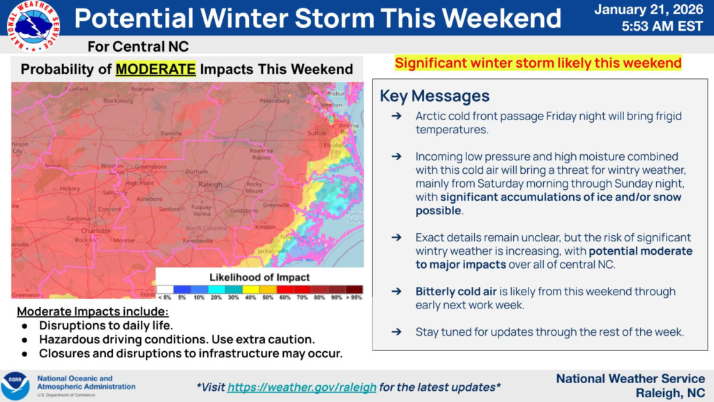
The Winter Storm Watch issued by the NWS forecast offices (Raleigh and Wilmington) covers a broad swath of central North Carolina, extending from areas around Person and Granville counties through Wake, Guilford, Alamance, and toward Johnston and Cumberland counties and beyond.
According to official guidance, the watch is in place from Saturday afternoon until Monday afternoon, with wintry precipitation expected to begin Saturday and continue into Sunday, tapering early Monday.
What Conditions Are Possible
Forecasts indicate a complex winter weather setup with a mix of:
- Snow at the onset in some areas
- Sleet and freezing rain as temperatures hover near or below freezing
- Rain transitioning to ice and snow in others, depending on the storm track and timing of the cold air.
The potential exists for at least light to moderate ice accumulation where freezing rain persists — enough to make roads, bridges and sidewalks very slick and hazardous. Forecast products show that icy surfaces and slick conditions could continue into early next week after the precipitation ends if cold air lingers.
Hazard Risks Highlighted
The Winter Storm Watch reflects concern about travel disruptions and dangerous conditions:
- Roadways and bridges likely becoming icy as temperatures fall and precipitation transitions to freezing rain and sleet.
- Accumulations of ice on elevated surfaces could make travel treacherous and increase the risk of slips and falls.
- Cold air behind the system may keep temperatures below freezing through early next week, meaning any ice that forms may linger and maintain hazardous conditions on treated or untreated surfaces.
Preparation and Outlook
Residents across the watch area — including the Raleigh-Durham, Greensboro-Winston-Salem, and Fayetteville regions — are urged to monitor updated forecasts from the National Weather Service, especially as small changes in storm track can significantly affect precipitation type and intensity.
Officials remind the public that a Winter Storm Watch is issued when there is the potential for significant winter weather, including snow, freezing rain or sleet that could make travel difficult and hazardous. Watches are a call to prepare — a step before warnings may be issued as confidence increases.


