


TENNESSEE — A Winter Storm Watch is in effect across much of Tennessee this weekend as a major winter weather system — part of a large storm affecting much of the central and eastern U.S. — moves into the region. The National Weather Service’s Nashville office says the watch signals the potential for significant snow, sleet and ice between Friday night and Sunday morning.
Snow and Ice Expectations
Forecasters note that snow and winter precipitation could vary widely across Tennessee:
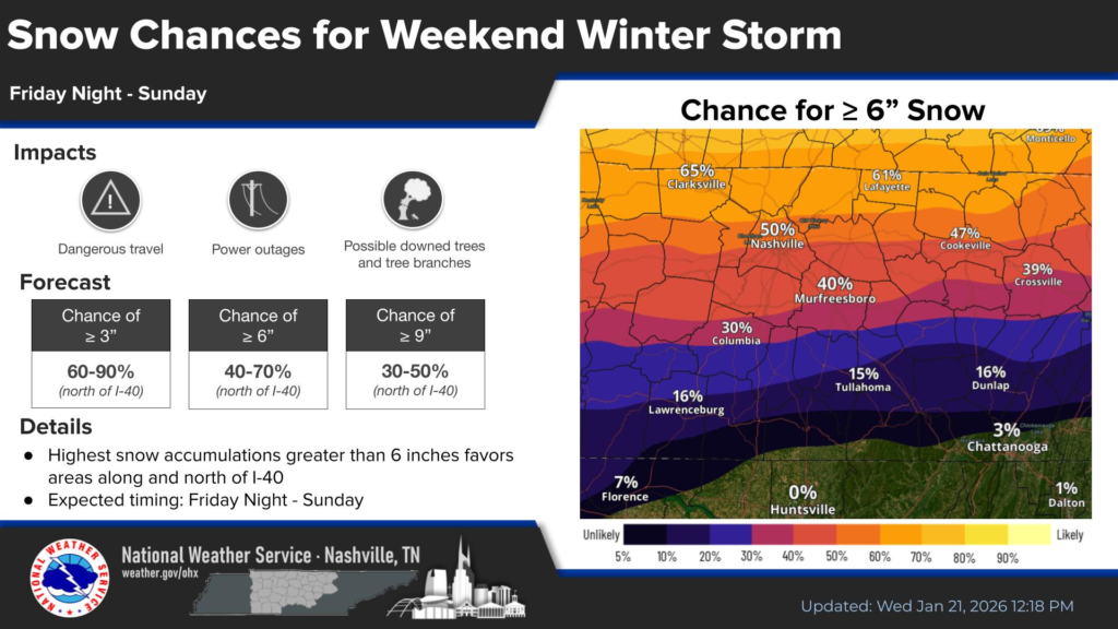
- Areas north of Interstate 40, including much of Middle and West Tennessee, have the highest probability of at least 6 inches of snow, with localized amounts potentially higher depending on exact storm track and elevation.
- In southern and central Tennessee, where temperatures may be closer to freezing at times, a wintry mix of snow, sleet and light ice accumulations is possible. Ice accumulations could reach around a light glaze or more in spots, especially south of I-40.
- The storm’s impact could include dangerous travel conditions, power outages, and downed branches or treeswhere ice coats outdoor surfaces.
Timing and Pattern
The Winter Storm Watch covers the period from Friday night through Sunday morning, with the bulk of wintry precipitation expected Saturday into early Sunday. Snow and sleet will likely begin along and north of I-40 before spreading southward and mixing with freezing rain closer to the Alabama and Mississippi lines.
Behind the system, arctic cold air will settle in, causing temperatures to fall well below freezing late weekend into early next week. This could prolong hazardous conditions on roads and bridges long after precipitation ends.
Preparedness and Impact
The Winter Storm Watch is a call to prepare — not a guarantee of exact amounts — but underscores the potential for significant snow and mixed wintry precipitation that could make travel dangerous or impossible at times. Residents are urged to:
- Monitor updated forecasts and warnings for their specific county.
- Prepare for slick roads, reduced visibility and power disruptions.
- Recognize that cold conditions may keep snow and ice on surfaces into early next week.
Local districts and emergency officials will be watching closely to determine if portions of the watch area warrant Winter Storm Warnings as confidence increases in the timing and severity of snow and ice.


