


LOUISIANA — The National Weather Service in Shreveport, Louisiana has placed much of northern and central Louisiana under a Winter Storm Watch in anticipation of a significant winter weather system expected to affect the state from Friday morning through Sunday morning. The watch reflects growing confidence that freezing rain, sleet, and snow could impact the region this weekend.
Where the Watch Applies
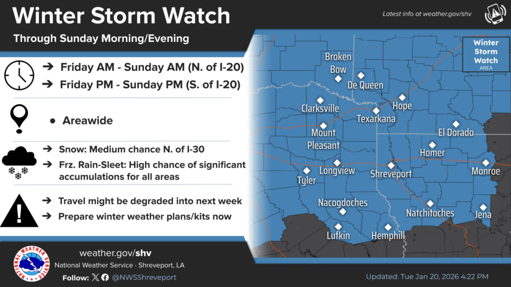
The Winter Storm Watch covers a large area including parishes across northwest and north central Louisiana, such as Caddo, Bossier, Webster, Claiborne, Bienville, Red River, Natchitoches, Lincoln, Union, Ouachita, Jackson, Caldwell, Winn, and Grant, among others.
What the Watch Means
A Winter Storm Watch is issued when there is the potential for significant winter precipitation — including snow, sleet, and freezing rain — that could make travel hazardous. This watch serves as an early alert for residents to begin preparations.
According to the Shreveport forecast office, the region could see a mix of precipitation types this weekend with medium chances of measurable snow north of Interstate 30 and higher chances of sleet and freezing rain accumulations across much of the watch area. Extended sub-freezing temperatures are also expected, with many areas forecast to experience multiple days of below-freezing conditions during and after the storm.
Timing and Impacts
- Friday through Sunday morning is the window covered by the watch, with wintry precipitation expected to begin Friday morning or afternoon and continue through Saturday into early Sunday.
- Freezing rain and sleet are likely concerns for much of the watch area, with ice accumulations possible where temperatures remain below freezing.
- Snow is possible in northern parts of the state, though amounts and locations remain uncertain.
What Residents Should Do
Officials urge residents in the watch area to:
- Monitor updated forecasts from the National Weather Service.
- Prepare for hazardous travel conditions due to ice and snow.
- Consider plans for extended cold and frozen precipitation, including potential impacts on roads, power, and daily routines.
The watch may be upgraded to a Winter Storm Warning or other products (such as an Ice Storm Warning) as forecast confidence increases and impacts become clearer later this week.


