


NORTH CAROLINA — Winter storm warnings and advisories have been issued for multiple counties across western North Carolina, where several inches of snow and strong winds are expected from midnight tonight through midnight Monday night, according to the National Weather Service.
Avery County
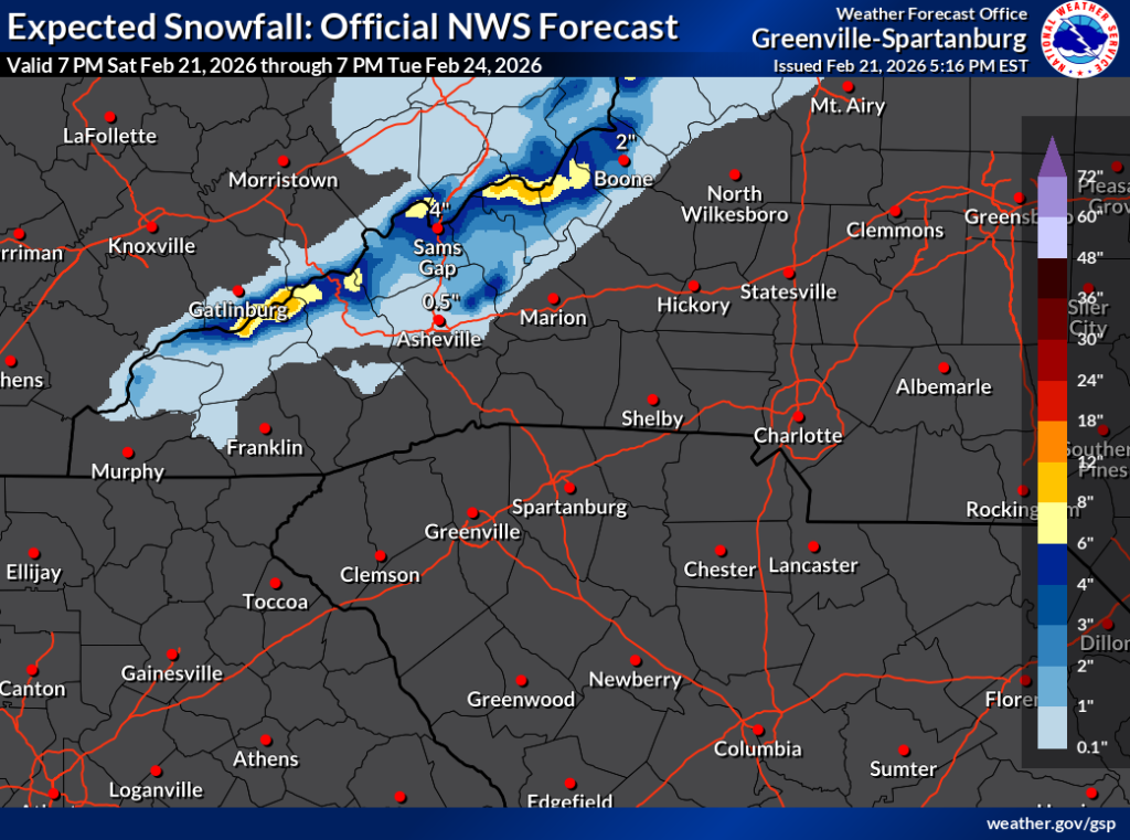
A Winter Storm Warning is in effect for Avery County, including Banner Elk, Newland and Ingalls. Forecasters say heavy snow is expected, with total accumulations generally between 2 and 6 inches. Higher elevations along the Tennessee border could see up to 10 inches.
Winds could gust as high as 50 mph, creating blowing snow and periods of very low visibility, especially Sunday night and Monday. Officials warn that many roads could become impassable, and scattered power outages are possible due to the weight of snow on trees and power lines. Travel conditions are expected to deteriorate, particularly during the Monday morning and evening commutes.
Mitchell County
Mitchell County, including Spruce Pine and Poplar, is under a Winter Storm Warning above 3,500 feet and a Winter Weather Advisory below that elevation.
In higher elevations, 5 to 10 inches of snow are expected. Lower elevations could see between 1 and 4 inches, with higher totals near the Tennessee border. Wind gusts up to 50 mph may lead to blowing snow and hazardous travel conditions. Roads in the mountains may become impassable, and isolated power outages are possible.
Swain County
A Winter Weather Advisory is in effect for the high elevations of Swain County. Snowfall totals between 3 and 7 inches are expected above 3,500 feet, with up to a foot or more possible on the highest peaks of the Smoky Mountains. Valleys could see up to an inch.
Winds gusting between 35 and 45 mph may cause blowing snow and sharply reduced visibility in higher terrain. Travel in mountainous areas could become dangerous or impossible at times.
Haywood County, Madison County and Yancey County
A Winter Weather Advisory has also been issued for Haywood, Madison and Yancey counties, including communities such as Waynesville, Burnsville, Marshall, Mars Hill and Canton.
Valley areas are expected to receive 1 to 3 inches of snow, while higher elevations along the Tennessee border could see 4 to 7 inches, with locally higher amounts possible. Wind gusts may reach 50 mph in the mountains, producing blowing snow and very low visibility Sunday night into Monday.
Ashe County and Watauga County
A Winter Weather Advisory is in effect for Ashe and Watauga counties, including Boone and West Jefferson.
Up to 4 inches of snow are forecast, with locally higher amounts above 4,000 feet. Wind gusts could reach 45 mph. Slippery roads are expected, and falling temperatures Sunday night may drop into the teens, with wind chills in the single digits.
Officials urge residents to monitor updated forecasts, slow down if traveling and check road conditions by calling 511. Motorists are encouraged to keep emergency supplies in their vehicles in case travel becomes delayed or stranded.


