


INDIANA — A Winter Storm Watch is in effect for southern and parts of central Indiana from early Saturday morning through Monday morning, as meteorologists track a significant winter weather system expected to impact the region this weekend. The watch was issued by the National Weather Service forecast offices covering Indiana and nearby areasand reflects the growing likelihood of accumulating snow and wintry precipitation.
Where the Watch Applies
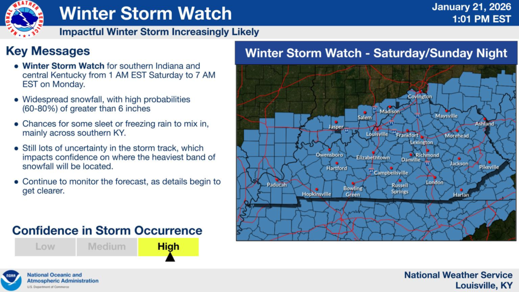
The Winter Storm Watch includes portions of south central and southeastern Indiana, closely tied into the broader watch area that extends into central Kentucky and eastern Illinois. Specific zones under the watch encompass counties from near the Ohio River northward toward the Interstate-70 corridor, with the exact list maintained on the NWS website.
Forecast and Timing
- Timing: The watch is valid from early Saturday morning through Monday morning, covering the period when snow and wintry precipitation are most likely to occur.
- Precipitation: Forecasters anticipate periods of moderate to heavy snow, with potential snow totals reaching several inches depending on storm track and intensity. Some mixing with sleet is also possible, especially near the southern edges of the watch area.
- Cold: This system is part of a broader pattern of Arctic air spreading across the Midwest and Ohio Valley, which will bring very cold temperatures and below-normal conditions into next week.
Impacts to Travel and Daily Life
The National Weather Service warns that travel could become difficult or dangerous during the storm due to accumulating snow and cold temperatures. There is concern that roads, bridges and overpasses could be snow-covered, especially during peak snow periods Saturday through Sunday.
Preparation and Outlook
Residents are urged to monitor local forecasts and prepare for winter weather impacts, including:
- Planning for slippery and hazardous road conditions this weekend.
- Staying updated on any upgrades to Winter Storm Warnings or advisories as the forecast evolves.
- Being aware that cold temperatures may linger into early next week, potentially extending impacts on travel and outdoor activities.
The watch may be upgraded to a Winter Storm Warning as timing and snowfall amounts become more certain later this week.


