


VIRGINIA — Winter weather advisories now stretch across much of western, southwest and northern Virginia as multiple rounds of snow are expected from late Saturday night through Monday.
The National Weather Service has issued advisories for counties in southwest Virginia, the Shenandoah Valley, the northern Piedmont and areas near Washington, D.C.
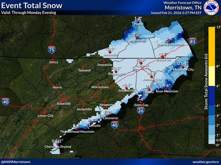
Southwest Virginia
In Russell, Washington and Wise counties — including Honaker, Bristol, Norton, Lebanon, Coeburn, Hansonville, Rosedale, Wise, Abingdon, Appalachia, Castlewood and Big Stone Gap — two rounds of snow are expected from midnight through Monday night. Forecasters predict 1 to 3 inches of accumulation above 2,500 feet, with isolated higher totals over the highest peaks. Winds may gust up to 35 mph.
Buchanan and Dickenson counties, including Grundy, Hurley, Vansant and Clintwood, are forecast to receive between 2 and 4 inches of snow through early Tuesday.
Bland, Giles and Bath counties — including Pearisburg, Hot Springs and Bland — could see up to 3 inches of snow, with wind gusts as high as 40 mph.
Northern and Central Virginia
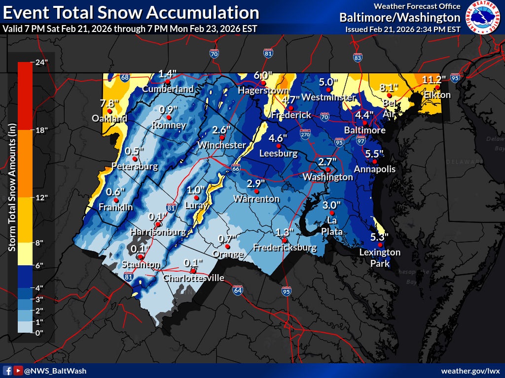
A separate advisory is in effect from Sunday evening into Monday morning for Spotsylvania, Culpeper, Stafford, Rappahannock, Southern Fauquier and King George counties. Snowfall totals of 1 to 3 inches are expected, with wind gusts up to 35 mph.
Additional advisories cover Shenandoah, Frederick, Page and Warren counties in northwest Virginia, where 2 to 4 inches of snow are possible in the higher hills, with lighter amounts in valley locations.
In Northern Virginia, including Fairfax County, Arlington, Alexandria, Northern Fauquier and Prince William County, 2 to 4 inches of snow are forecast from late Sunday afternoon through Monday morning. The snowfall could create slick road conditions during the Monday morning commute.
Travel Impacts
Across all affected areas, roads — especially bridges and overpasses — are expected to become slippery. Gusty winds may cause brief reductions in visibility and areas of blowing snow.
Officials warn that hazardous conditions could significantly impact the Monday morning commute statewide, particularly in higher elevations and northern counties.
Drivers are urged to slow down and use caution. Updated road conditions are available by calling 511.


