


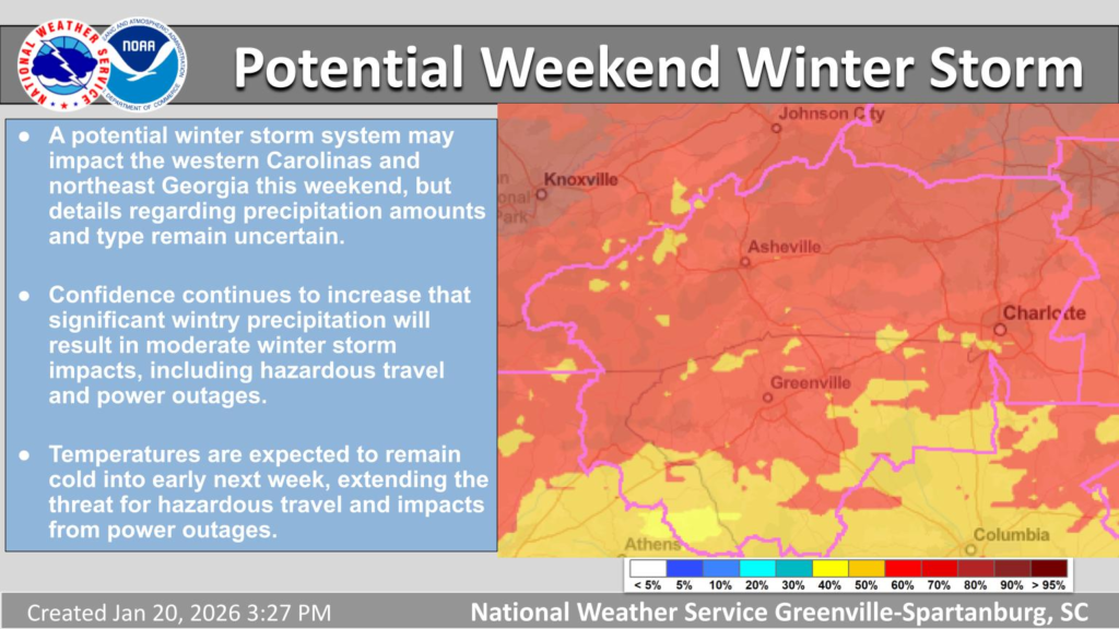
NORTH CAROLINA — A potentially significant winter storm is taking shape and could impact much of North Carolina over the upcoming weekend, according to National Weather Service offices and multiple regional meteorologists.
Forecast models increasingly indicate that a strong combination of Arctic air and an active storm system will produce snow, sleet, freezing rain and dangerously cold temperatures across the state Saturday and Sunday.
WHAT THE FORECAST SHOWS
Meteorologists are tracking a developing low-pressure system that will interact with an incoming Arctic air mass across the Southern United States. This setup is typical of high-impact winter weather when cold air sits over a region as moisture moves in from the Gulf of Mexico.
According to preliminary forecasts:
- Precipitation is likely to begin Friday as rain in lower elevations before transitioning to wintry forms as temperatures fall.
- Saturday through Sunday is when the wintry precipitation is expected to peak, with snow, sleet and freezing rain possible across much of the state.
- Temperatures are forecast to drop significantly this weekend, with highs in many areas struggling to climb above freezing.
In parts of central and eastern North Carolina, the storm could produce mixed precipitation types — meaning that snowfall could change to sleet or freezing rain depending on local temperatures and storm track.
POTENTIAL IMPACTS
Officials warn that travel could become dangerous to impossible in many areas this weekend:
- Snow and ice accumulation could make roads slick and hazardous.
- Freezing rain — which is particularly damaging — may accumulate on elevated surfaces such as power lines and tree branches, raising the risk of power outages and structural damage.
- Meteorologists note that, while exact precipitation amounts remain uncertain this far ahead of the storm, the risk for significant winter weather impacts is increasing.
The National Weather Service in Raleigh has urged residents in central North Carolina to begin preparing now, including checking emergency supplies and planning for extended periods at home if travel becomes unsafe.
FORECAST UNCERTAINTY REMAINS
Despite growing confidence in a storm system this weekend, forecasters emphasize that key details — such as where the transition zones between snow, sleet and freezing rain will set up — are still unsettled. These details will be refined as the event draws closer and additional weather model data is ingested.
Mountain and northern counties are generally expected to see more snow, whereas southern and coastal regions may experience a mix of ice and rain before the storm departs.
PREPARATIONS AND SAFETY
Residents are being advised to:
- Monitor forecast updates throughout the week.
- Ensure adequate supplies of food, water, medications and heating fuel.
- Avoid unnecessary travel during the weekend if the storm materializes as forecasted.
Meteorologists will continue issuing more detailed area-specific guidance as the storm approaches later in the week.


