


SOUTH CAROLINA — A Winter Storm Watch is in effect across large portions of South Carolina as a significant winter weather system is expected to impact the state from Saturday morning through early Monday afternoon. The watch was issued by the National Weather Service Greenville-Spartanburg Forecast Office and covers the upstate, central, and portions of eastern South Carolina.
Watch Details and Timing
- Validity: The Winter Storm Watch runs from Saturday morning through early Monday afternoon, spanning most of the weekend when wintry precipitation is most likely.
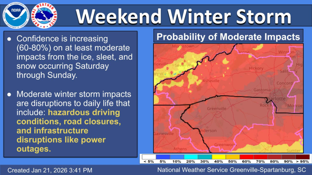
- The watch reflects a growing threat of **mixed winter precipitation — including snow, sleet, and significant ice accumulations — that could create hazardous travel conditions and infrastructure impacts.
Precipitation Type and Accumulation Trends
Forecast discussions from the Greenville-Spartanburg office show that snow totals have trended down slightly while ice and sleet accumulations have trended upward in the latest model guidance. This means freezing rain and ice are expected to be major winter weather threats in the Carolinas this weekend, not just snow.
Hazard Risks Highlighted
The Winter Storm Watch indicates the potential for:
- Hazardous travel conditions across much of the state due to ice, sleet, and snow.
- Significant ice accumulations that can make roads, bridges, and overpasses dangerously slick.
- Power outages and infrastructure impacts as ice builds on trees and utility lines, which could persist beyond the storm’s departure.
Expected Impacts and Preparation
Residents are urged to monitor updated forecasts closely as small shifts in the storm track can significantly change when and where ice and snow fall. The National Weather Service notes that hazardous conditions and potential power outages may last for days, extending into early next week, even after wintry precipitation ends.
Because of the potentially widespread impacts and extended cold behind the system, the Winter Storm Watch may be upgraded to a Winter Storm Warning or Ice Storm Warning as confidence increases in specific accumulations and storm timing.


