


OHIO — Ohio is bracing for a significant winter storm this weekend as a powerful system moves across the Midwest, prompting official winter storm warnings and heavy snow forecasts from the National Weather Service and local meteorologists.
Winter Storm Warnings in Effect
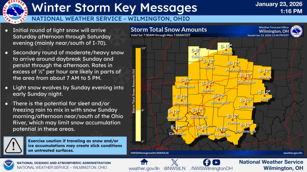
The National Weather Service has issued Winter Storm Warnings for much of the state beginning Saturday and continuing into Monday, depending on region. These warnings indicate expected heavy snowfall and hazardous conditions that could make travel dangerous and disrupt daily life.
Ahead of the snow, a Cold Weather Advisory is already in place across central and northern Ohio, signaling bitter temperatures and wind chills that could pose risks of frostbite or hypothermia if precautions aren’t taken.
Snow Forecast: How Much and Where
Forecasts show that snow will begin later Saturday or Saturday night, intensifying through Sunday and tapering off by Monday. Official projections and local weather coverage put statewide snow totals in these general ranges:
- Central Ohio (Columbus area) — 6 to 12 inches of snow is likely as bands of snow push through the region.
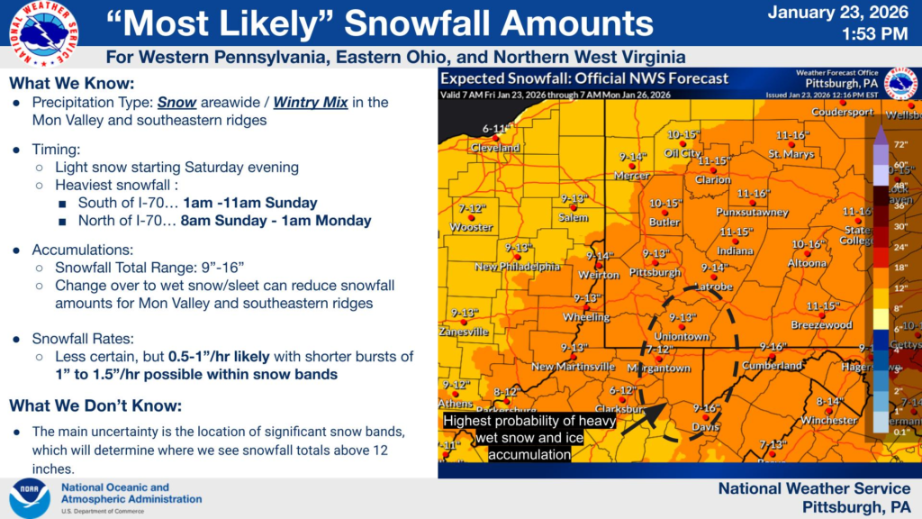
- Northeast Ohio (including Cleveland, Akron areas) — 6 to 10 inches, with higher totals across southern parts of the viewing region.
- Southern and Western Ohio (Cincinnati and southwest) — 8 to 12+ inches possible, with the potential of sleet mixing in briefly before snow resumes.
- Northern Ohio & Northwest counties — Models and local offices suggest 6 to 12 inches of accumulating snow, with isolated higher amounts possible.
Lake-enhanced snow — extra snowfall driven by cool air blowing over Lake Erie — may boost totals in areas close to the lake, especially downwind counties.
Timing and Conditions
Across most of Ohio, snow is expected to begin Saturday afternoon or evening, with steadier snow through Sunday. The heaviest snow will likely fall Sunday into Sunday night, making travel especially hazardous during peak travel times.
In addition to snowfall, cold temperatures will stick around well after the storm, with dangerous wind chills and persistent below-average readings continuing into early next week.
Expected Impacts
Officials are warning residents to prepare for:
- Dangerous travel conditions — slick roads, low visibility and drifting snow can make driving treacherous.
- School and business disruptions — many districts have already announced closures or delays.
- Cold injuries — prolonged exposure in the frigid air could lead to frostbite or hypothermia.
Authorities recommend that Ohioans stock up on essentials, limit travel during the storm’s peak, and stay updated with local weather and safety advisories.
This storm is part of a broader system impacting much of the United States, with heavy snow and Arctic air reaching from the Midwest into the East Coast this weekend.


